Download
1 / 1
10 likes | 121 Vues
Jackson Co. EF-4 tornado track. Smithville, MS Storm. Hackleburg-Phil Campbell-Tanner Storm. Waves. Waves. Waves. Jackson Co. EF-4 tornado track. Hackleburg-Phil Campbell-Tanner Storm. Smithville, MS Storm. Waves. New Storm. Wave. Waves. Jackson Co. EF-4 tornado track.

E N D
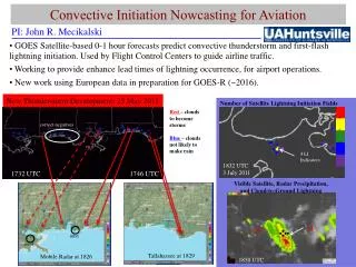
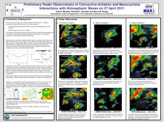
Jackson Co. EF-4 tornado track Smithville, MS Storm Hackleburg-Phil Campbell-Tanner Storm Waves Waves Waves Jackson Co. EF-4 tornado track Hackleburg-Phil Campbell-Tanner Storm Smithville, MS Storm Waves New Storm Wave Waves Jackson Co. EF-4 tornado track Hackleburg-Phil Campbell-Tanner Storm Smithville, MS Storm New Storm – Eventual Limestone-Madison County EF-1 Tornado Wave Waves Preliminary Radar Observations of Convective Initiation and Mesocyclone Interactions with Atmospheric Waves on 27 April 2011 Todd A. Murphy, Timothy A. Coleman, and Kevin R. Knupp Atmospheric Science Department, The University of Alabama in Huntsville P1.28 1. Introduction & Background 2. Radar Observations • During the historic deep south tornado outbreak of 27 April 2011, numerous instances of radar identified waves1 were observed either: • Interacting with already present mesocyclones and modulating the storm’s intensity. • Being a trigger for convective initiation. • Some cases of wave-mesocyclone interaction were associated with tornadogenesis or a change in the degree of damage along the tornado path, as indicated by changes in the Enhanced Fujita (EF) scale rating. • Observations of convective interactions with waves and initiation from waves have been made since the 1970s (Uccellini 1975; Miller and Sanders 1980; Stobie et al. 1983; Koch et al. 1988; Kilduff 1999). Recently, Coleman and Knupp (2008) found that interactions of ducted gravity waves with preexisting mesocyclones can increase the vorticity of the mesocyclone through convergence-divergence and perturbation wind shear associated with the wave. • Left Image: Airflow vectors and an isentrope (heavy solid curve) in the x-z plane for a ducted gravity wave. Divergence is largest near the surface, with convergence ahead of the wave ridge and divergence ahead of the trough. Positive perturbation shear is centered in the wave trough and negative shear centered in the ridge. Pressure perturbations associated with the wave are also indicated (Coleman and Knupp 2008). • Right Image: Regions of positive wave-induced stretching and tilting, relative to the wave phase, during a mesocyclone-wave interaction (Coleman and Knupp 2008). • Additionally, it appeared the low lifting condensation level (LCL) and level of free convection (LFC) observed during 27 April allowed for the vertical velocities associated with the waves to trigger convection that eventually developed into supercell thunderstorms. Reflectivity (Z) values in some wave features approached 55 dBZ • Left Image: Schematic of vertical motion associated with a wave and the associated cloud due to the vertical ascent LCL reached (Adapted from Koch and O’Handley 1997). • Middle and Right Image: LCL and LFC heights (m AGL) at 19 UTC over the Southeastern United States. • 1 Waves are identified on radar as distinct horizontal lines or arcs of weak to moderate reflectivity that are observed propagating faster than the (wave parallel) background wind speed. a) Convective Initiation b) Wave Interaction c) Wave Interaction ARMOR Reflectivity – 2028 UTC Horizontal lines of enhanced Z were observed on ARMOR moving from 215°at near 36 m s-1 south of the supercell producing the Cullman tornado. KGWX Reflectivity – 1942 UTC Arc shaped lines of moderate Z were initially observed propagating from 200-215°at near 25-30 m s-1 south of KGWX in Mississippi. KHTX Reflectivity – 2120 UTC Horizontal lines of moderate reflectivity were observed propagating from 220°at near 33-38 m s-1 south of a supercell that had not yet produced a tornado. KGWX Reflectivity – 2019 UTC Maximum Z and the height of maximum Z increased in the waves by 2000 UTC. Shortly after, it appeared waves were a trigger point for the development of a supercell. ARMOR Reflectivity – 2040 UTC In this case, wave interactions were coincident with the dissipation of the Cullman EF-4 tornado in Marshall County, AL KHTX Reflectivity – 2139 UTC By 2139, one wave crest (enhanced Z) had intercepted the supercell. No significant change in rotational velocity observed. KGWX Reflectivity – 2033 UTC The wave energy continued to move to the north-northeast while the triggered storm immediately began to move to the right of the mean wind (supercell development) ARMOR Reflectivity – 2048 UTC Finally, further wave interactions were coincident with the re-development of a tornado in Jackson County, AL (Jackson-DeKalb Co. EF-4) KHTX Reflectivity – 2153 UTC The second wave crest intercepted the supercell by 2153 UTC. Shortly after this interaction, the supercell developed a tornado that eventually went on to do EF-4 damage in Jackson County, AL. Acknowledgements: This research is supported by NSF Grant AGS-1140387