Download
1 / 24
240 likes | 262 Vues
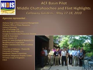
This presentation provides an overview of the National Water Quality Network in the Delaware River Basin, including national and local issues, partners, pilot study area, resource components snapshots, data management status, and nutrient analysis. It also discusses the water quality issues, technical needs, and monitoring efforts in the basin.

E N D
National Water Quality Network: Delaware River Basin Pilot NWQMC Meeting Philadelphia, PA: July 2007
Presentation Overview • National Issues/DRB Issues • DRB Partners • DRB Pilot Study Area • Resource Components Snapshots • Data Management Status • “Dry Run” Nutrient Analysis
Basin Facts • Largest un-dammed river east of the Mississippi – 330 miles • 13,539 square mile drainage • 17 million water users • 216 tributaries • Three reaches included in National Wild and Scenic River System • One of the world’s largest freshwater tidal estuaries • Delaware Bay- 782 sq. miles • One five MACOORA subregions
Monitoring Partners in the Delaware River Basin
Table 1-1: Water Quality Issues from NMN Report • Oxygen depletion • Nutrient enrichment (arguable) • Toxic contamination • Sedimentation • Harmful algal blooms • Habitat degradation • Invasions by exotic species • Pathogens (indicator bacteria)
Chair: Bob Tudor, DRBC Organizations participating: DRBC, MACOORA USEPA Regions 2 & 3 NOAA USGS NJ, PA, DE, NY and NAWQA NJDEP, DNREC, PADEP, NYDEC Rutgers, UDel PDE Set boundaries for study area Integrate with NMN Interagency Work Groups Coordinate DRB Work Group efforts Data Management efforts Other DRB Pilot Work Groups Data Management Atmosphere Rivers above head of tide Estuary Near shore Off Shore Wetlands Ground water Delaware River Basin Pilot Steering Committee
DRB Pilot Study Area Boundary • Entire Delaware Basin • 4 states—NY, PA, NJ, DE • Several Physiographic Provinces and Ecohabitats • Major inflows—Lehigh, Schuylkill, Maurice, C&D Canal • Bounded by northern and southern Coastal endurance lines
Data Management Work Group Chairs: Eric Vowinkel and Ed Santoro • Existing DRBC Monitoring Matrix • Will create an ftp site on DRBC computer to store exchange of information • Water-Quality Data Exchange (WQDE) Networks in progress at NJDEP, DNREC, PA?, NY? • Exploring options for web-based portal for Delaware Basin http://www.delawareestuary.org/Info_gateway/Main_map.asp
Estuary Work Group Chair: Jonathan Sharp, UDel • Boat Run—historical monitoring along spine of Delaware Estuary • Probabilistic network • NCA • New sites from USEPA Corvallis from Tony Olsen • Discussions of mixing probabilistic and fixed stations
Chair: Bob Connell, NJDEP Issues How far south? 12-miles out into Atlantic Ocean Physical habitat needs Sediments included Biological assessment and productivity Lidar methods—remote sensing Should not be looking at nutrients but rather eutrophic conditions Chlorophyll a, DO, macro algae, HABS, nutrient loads, wastewater discharges, atmospheric deposition Assests Gliders Air craft and satellite remote sensing Boat along coast with NJDEP & USEPA Fixed station LEO site from RU DEOs fixed station Optical sensor for DO in future in glider Nuisance algal blooms-by boat Loads from WWTP Maybe some nutrient data from atmospheric Map will be coming Near-Shore Work Group
Off-Shore Work Group Chair: Scott Glenn, RU IMCS • Endurance line off of Tuckerton, NJ • Future site off of Delaware http://marine.rutgers.edu/cool/auvs/
Wetlands Work Group Tidal Wetlands: Signature Trait of System Extensive, Near Contiguous Band Diverse Types: Salt, Brackish and Freshwater Tidal Marshes Ecological Values: Structural biodiversity habitat for fish & wildlife nurseries, imperiled taxa Functional food web water quality flood protection Rutgers University • Chair: Danielle Kreeger, PDE
Philadelphia Tidal Wetlands <5% of freshwater tidal marshes remain Concerns: • Degradation • Conversion and Loss • Sea Level Rise • Sediment supply • Sudden Marsh Die-Back • Storms With sea level and salinity rise, where will they go? Spills
Atmosphere Work Group Chair: Lisa Totten, Rutgers • Only one NADP site in the Basin • Supplemental sites added by NJDEP, DRBC • Some sites deactivated
Ground Water Work Group Chair: Eric Vowinkel, USGS • Significant vulnerability of ground water in the Delaware Basin to contamination by nitrate in PA, NJ, and DE • Concentrations of nitrate in ground water are largest in agricultural areas and moderate in urban area http://pubs.usgs.gov/sir/2004/5118/SIR2004-5118.pdf
What was done Compared Nutrient IWG recommendations Tier 1—required Tier 2—add significant value Response variables Ancilliary For Delaware River at Trenton as test case (see table) For Delaware Estuary Boat Run Data Results Delaware at Trenton site monitored 4-6 times per year for DRBC and PADEP Will be monitored 16 times per year for NAWQA Status and Trends in 2008 for nutrients and pesticides but only once every four years Site location data well documented Metadata and QA/QC well documented Only Tier 1 nutrients satisfied except for silica Did not meet detection limit for most constituents by more than an order of magnitude For Estuary Boat Run more constituents were analyzed for in the different Tiers but generally did not meet the detection limit requirements for nutrients Nutrient dry run