Download
1 / 10
100 likes | 847 Vues
GLACIAL ENVIRONMENTS 4 Periglacial processes and landforms: permafrost frost heave, contraction and nivation periglacial landforms.

E N D
GLACIAL ENVIRONMENTS 4 • Periglacial processes and landforms: • permafrost • frost heave, contraction and nivation • periglacial landforms
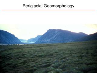
Periglaciation is a set of processes that happen in areas near to ice sheets e.g. Alaska or in very cold mountain areas e.g. Himalayas. These processes produce a unique set of periglacial landforms. Many areas in Europe and North America show evidence of relic periglacial processes from the last Ice Age. A key characteristic of periglacial areas is permafrost or permanently frozen ground. Today, permafrost still covers 25% of the Earth’s surface although this figure is declining due to global warming. The depth and continuity of the permafrost vary with latitude, altitude and ocean currents. Map source:http://atlas.nrcan.gc.ca/site/english/index.html Diagram source: http://gsc.nrcan.gc.ca/permafrost/images/wheredoes2.jpg
In Northern Canada continuous permafrost extends down to depths of around 700 metres. Here mean annual air temperatures is below -5°C and winter temperatures may fall to -50°C. In summer only the top of the ground will thaw. This unfrozen surface layer is known as the active layer. The active layer varies from a few centimetres to about 5 metres and even on gentle slopes this saturated layer can become very mobile. Below the active layer, ground temperatures fluctuate but remain below freezing point. The unfrozen layer beneath the active layer is known as talik. The lower limit of the talik (permafrost base) is determined by geothermal heat rising up from the mantle. Diagram source: http://gsc.nrcan.gc.ca/permafrost/whatis_e.php
In general, the periglacial processes remain poorly understood and there is debate as to whether the processes were more active in the past than now. An increasing amount of research has been done as humans have tried to exploit the resources, particularly oil, in these difficult environments. An important process in periglacial areas is frost heave. This results from ice crystals or ice lenses forming in fine-grained soils. As the ice expands, the ground above is domed up and stones get pushed to the surface. Frozen ground cracks and forms patterned ground in which loose stones fall into the cracks to highlight the outlines. These so-called stone polygons vary from 1-5 metres in diameter. On slopes above 2°, the stone polygons become stretched and may form stone stripes. Photo source:http://sis.agr.gc.ca/cansis/taxa/landscape/ground/sorted_nets_nt.jpg Photo source: http://www.mun.ca/botgarden/limestonebarrens/Geology.htm
In winter, the active layer freezes and the soil layer contracts and forms natural polygonal patterns. The following summer, the cracks may close up or sometimes become filled with meltwater and debris. In the subsequent winter, any water filled cracks expand as ice forms and the cracks widen to form ice wedges. Photos source: http://gsc.nrcan.gc.ca/beaufort/images/ground_ice3.jpg Repeated freezing and thawing leads to wedges a metre wide and up to three metres deep. In the UK, fossil ice wedges can be found in many areas. The cracks are filled with sand and silt deposited by meltwater. Ice-wedge polygons can be distinguished from the stone polygons by their greater size (up to 30 metres across) and the depression, rather than a dome at the centre. Photo source: http://www.ucalgary.ca/~dgsmit/duane.jpg
In a periglacial landscape, the most dramatic landform is the pingo. These are dome-shaped hills which may rise to around 50 metres above the generally flat tundra landscape. Some of the pingos have depressions in their surfaces and some have ice cores at their centre. Photo source: http://www.geo.uu.nl/fg/berendsen/pictures/photography/alaska/Pingo.jpg It is believed that the origins of these landforms may vary and two types are now recognized – the open system (hydraulic) pingos and the closed-system (hydrostatic) pingos. Diagram source: http://www.erudit.org/revue/gpq/1998/v52/n3/004847ar.html
Open-system (hydraulic) pingos occur in valley bottoms and in areas of thin or discontinuous permafrost. They are common in East Greenland. When the surface layer freezes, water is trapped in the talik (unfrozen layer). This water comes under pressure and may move towards the surface where, surrounded by permafrost, it freezes into an ice core. This causes the surface to dome upwards. As water under pressure finds its way to the surface, the ice dome and thus the pingo, continues to grow. Photo source: http://sis.agr.gc.ca/cansis/taxa/landscape/ground/ice_wedge_nt2.jpg
Closed-system (hydrostatic) pingos are generally found in lowland areas where permafrost is more continuous. They often form on the sites of small lakes. As these lakes fill with sediments from meltwater, the surrounding permafrost advances and squeezes the unfrozen sediments below the lake. When the lake itself is frozen, the water in the underlying sediments causes the surface to dome upwards creating the pingo. If the dome cracks, the ice core may melt leading to a collapse of the pingo and a pond forming in the central crater. Diagram source: http://www.nsidc.net/fgdc/glossary/illustrations.pdf
Mass movement processes are very active in periglacial areas and help to shape the landscape in areas where there is gentle relief. Frost creep is common in the top 50 centimetres of soils in summer on steep slopes. Ice crystals in the soil push up stones and soil particles which collapse back when the ice melts. In this way the stones and soil particles zigzag their way down the slope moving perhaps 20-30 centimetres in a year. Solifluction (sometimes known as gelifluxion) is a more obvious process as it operates on a larger scale. In the short summer season, the saturated active layer sits on top of an impermeable frozen layer. The active layer is unstable on even quite gentle slopes of 1-2 degrees. As a result of this, the active layer becomes mobile, particularly in spring, and can flow large distances. The thin vegetation layer sometimes restricts movement but often breaks. Diagram source: http://www.school-portal.co.uk/GroupDownloadFile.asp?GroupId=5313&ResourceId=18976
Summary of key points: • periglaciation is a set of processes that happen in areas near to ice sheets • a key characteristic of periglacial areas is permafrost or permanently frozen ground • in summer, the ground may become unfrozen for a short while. This unfrozen surface layer is known as the active layer • An important process in periglacial areas is frost heave. This results from ice crystals or ice lenses forming in fine-grained soils. This leads to the formation of patterned ground • a second type of patterned ground forms due to ice wedges. These are created when the ground freezes and cracks • the most dramatic landform is the pingo. These are dome-shaped hills which may rise to around 50 m above the generally flat tundra landscape. Some of the pingos have depressions in their surfaces and some have ice cores at their centre • mass movement processes are very active in periglacial areas. On a small scale, soil creep moves material down steep slopes. On a larger scale, solifluction moves material on more gentle slopes