
Uploaded by
sondra
1 SLIDES
169 VUES
10LIKES
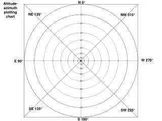
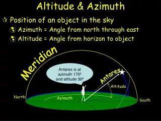
Altitude-Azimuth Plotting Chart for Sky Observation
DESCRIPTION
This altitude-azimuth plotting chart helps identify positions of celestial objects in the sky with degrees ranging from NE 135° to NW 315° and heights from 10° to 70°. Find accurate directions like W 270°, E 90°, and more for stargazing and navigation.
Download
1 / 1
Télécharger la présentation 
Altitude-Azimuth Plotting Chart for Sky Observation
An Image/Link below is provided (as is) to download presentation
Download Policy: Content on the Website is provided to you AS IS for your information and personal use and may not be sold / licensed / shared on other websites without getting consent from its author.
Content is provided to you AS IS for your information and personal use only.
Download presentation by click this link.
While downloading, if for some reason you are not able to download a presentation, the publisher may have deleted the file from their server.
During download, if you can't get a presentation, the file might be deleted by the publisher.
E N D
Presentation Transcript
N 0° Altitude-azimuthplotting chart NE 135° NW 315° 10° 20° 30° 40° 50° 60° 70° W 270° E 90° z 70° 60° 50° 40° 30° 20° 10° SE 135° SW 225° S 180°


More Related