Download
1 / 20
200 likes | 234 Vues
Watershed Watch Network. Danielle Donkersloot Volunteer Monitoring Coordinator. NJ Department of Environmental Protection. SUMMARY. NJ Watershed Watch Network Data Creditability “Tiered Approach” NJDEP Support of a Data Management System Standardizing Volunteers Collected Data

E N D
Watershed Watch Network Danielle Donkersloot Volunteer Monitoring Coordinator NJ Department of Environmental Protection
SUMMARY • NJ Watershed Watch Network • Data Creditability “Tiered Approach” • NJDEP Support of a Data Management System • Standardizing Volunteers Collected Data • Benefits to the Volunteer Community • Benefits to NJDEP
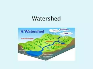
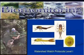
Watershed Watch Network • 29 River/Stream Monitoring Organizations • 58 Lake Monitoring Organizations
WWN Advisory Council • NGO, Volunteer Monitoring Coordinators • Volunteers (paid and unpaid) • EPA Region 2 • Office of Quality Assurance • Monitoring and Standards Program • Division of Watershed Management • Delaware River Basin Commission • Others as needed
The 4 Tiered Approach • Allows for volunteers to pick their level of monitoring involvement based on: • Intended purpose for monitoring • Intended data use • Intended data users
Options for Involvement • Tier A: Environmental Education • Tier B: Stewardship • Tier C: Community Assessment • Tier D: Indicators/Regulatory Response
Who Uses the Data in DEP? • Watershed Area Managers (TIERS B,C,D) • Water Assessment Team (TIER D) • NPS Program (TIER C, D) • 319 Program (TIER B, C, D) • TMDL Program (TIER B, C, D) • Other Programs or Divisions
THE STATE’S MONITORING MATRIX NJ Water Monitoring & Assessment Strategy 2005-2014 Volunteer collected data is now integrated into the NJDEP Monitoring Matrix: • Stream Monitoring • Lake Monitoring • Monitoring of Tidal Rivers & Estuaries • Wetland Monitoring
DATA, DATA, DATA Paper QAPP DEP Tiers? Study Design Study Design Schools electronic Volunteers
Creating the Data Management System • NJDEP & Volunteer Community can Access All Available Data • Volunteer Data will be Standardized • Volunteer Data will be available Geo-spatially & in DataMiner
Standardizing the Collection Methods of the Volunteer Community in NJ • Crosswalk of all volunteer program data sheets • chemical • biological • visual/habitat • general observations • Worked with volunteers coordinators & DEP to develop consistency
Volunteer Water Quality Monitoring Data Management System • Tie-in with National Initiatives • Quality Assurance • Project & Site Management • Assessment Report Options • Data Outputs (via Data Miner & NJEMS) • GIS Integration (via new version of iMAP)
Tie-in w/ National Initiatives • EPA currently piloting new data reporting system to feed national system (STORET) • OWWQX (Office of Water - Water Quality eXchange) • Will be eventual way in which data is fed to EPA • Based on EPA data standards (ESAR) • EPA / USGS currently working to harmonize data exchange between STORET and NWIS using OWWQX format • E2-WQM Module uses enhanced OWWQX XML schema for reporting format • Includes NJ-specific fieldsnot captured in national standard
Quality Assurance Project Plan Management • Each VM Project will be assigned a Tier • Electronic version of QAPP (or other similar Project Plan) can be uploaded to E2 • QAPP is then stored with the Project • QAPP can then be retrieved by Volunteer Monitoring Community or State by accessing online listing
Reporting Options • General Monitoring Information • 3 Types of Reports are included: • Visual / Habitat Assessments • Biological (macroinvertebrate) Assessments • Chemical Assessments • Each submission can include photos & additional files
Data Output Options Various data outputs being developed include: • Browse submission submitted data • Data Miner Reports/Graphs (once released) • Chemical values reported over time per site • Physical/meteorological parameters reported over time per site • Biological metric scores for multiple sites • Including whisker plots • Pie Chart showing reported macroinvertebrate breakdown for each assessment • iMap
GIS Integration (iMAP) • In lieu of providing GPS coordinates, users can select coordinates from a map for: • Site Identification (single point or river reach) • Pipe inventory/location • Drainage Ditch Inventory/location • Volunteer monitoring group can store completed reports without “releasing publicly”. • Data can then be “released” • Then it is available on the State’s GIS application • Monitoring Groups to be able to see data reported from other groups (once released)
The Real Test….. • Will the system be used by the VM community & DEP? • Will this be the “holy grail” of data management systems….? (Geoff Dates, 2005)
Danielle Donkersloot 609-292-2113 danielle.donkersloot@dep.state.nj.us http://www.nj.gov/dep/watershedmgt/volunteer_monitoring.htm