Mapping Our World
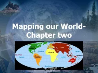
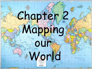
Mapping Our World. Chapter Two. The science of mapmaking is called cartography. Cartographers use an imaginary grid of parallel and vertical lines to locate points on Earth exactly.


Mapping Our World
E N D
Presentation Transcript
Mapping Our World Chapter Two
Cartographers use an imaginary grid of parallel and verticallines to locate points on Earth exactly.
The system set up by the long ago cartographers was helpful to ships at sea that could see no landmarks but could use the northstar to gauge their latitude.
The system is still used today by modern day ships with the help of computers and satellites.
The cartographer’s system is also used on land today, with the GPSsystem.
Equator The horizontal line that circles Earth halfway between the poles is called the equator and separates Earth into two equal halves called the northern and southern hemispheres.
Latitude Lines running parallel to the equator are called lines of latitude. Latitude, itself, is the distance in degrees north or south of the equator.
Locations north of the equator are referred to by degreesnorth latitude and are represented with an N Syracuse, New York is located at 430 N
Each degree of latitude can be further be broken down into 60 smaller units, called minutes, and denoted with a ‘ mark. 480 43’ 837’’
Each minute of latitude can also be broken down into 60 smaller units, called seconds, and denoted with a ‘’ mark. 480 43’ 837’’
Longitude To locate positions in east and west directions, cartographers use lines of longitude, also called meridians. Longitude lines run perpendicular to the equator.
Notice that longitude lines are notparallel. The closer to the poles you get, the shorter the distance between meridians until they all actually convergeat the poles.
Prime Meridian The primemeridian represents 00longitude and runs through Greenwich, England, home of the Royal Navy Observatory.
Points west of the prime meridian are numbered from 00 to 1800west longitude; points east are numbered 00 to 1800east longitude. Greenwich England
International Dateline 1800 longitude corresponds with the InternationalDateline, which sits mostly on the 1800 longitude line.
The International Date Line separates two consecutive calendardays. People crossing the line from East to the West skip forward a day. Those crossing from the West to the East repeat the day, numerically. We will go further into time zones in a little later.
Like latitude lines, longitude lines can also be broken down into minutes and seconds. 20 12’ 979’’
Latitude Longitude Prime Meridian West East Longitude = rungs of a ladder when it is lying down long ways Latitude = rungs of a ladder
That's about all there is to latitude and longitude coordinates! Here's some tips to remember: • Latitude is always given before longitude (49° N 100° E) • Latitudes are parallel, but longitudes are not • Degrees West and South are sometimes referred to as negative degrees (-12° -23° is the same as 12 S 23 W) • A place's latitude affects its climate, but its longitude does not. • Key longitude lines are the Prime Meridian (0°) and the International Date Line (180°) • Key latitude lines include the equator (0°), the north pole (900 N) and the south pole (900S)
Time Zones Earth is also divided into 24timezones because it takes Earth about 24 hours to rotate once on its axis. Each time zone represents a different hour and is 150wide, corresponding roughly to the lines of longitude.
The international dateline serves as the reference point for calendar days. People crossing the line from Eastto the Westskip forward a day.
The United States has sevendifferent timezones. We live in the Eastern Time Zone.
As you travel west, you subtract one hour for each time zone. At 3:00 p.m. E.T. in North Carolina, it is 2:00 p.m. C.T., 1:00 p.m. M.T., and 12:00 p.m. P.T.
As you travel east, you add one hour for each time zone. At 3:00 p.m. P.T. in California, it is 4:00 p.m. M.T., 5:00 p.m. C.T., and 6:00 p.m. E.T. in North Carolina.