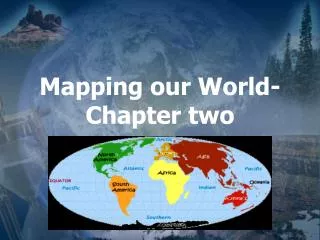
Mapping Our World
Mapping Our World. Latitude and Longitude Cartography Science of mapmaking Uses imaginary grid of parallel lines and vertical lines to locate points on earth Equator cuts Earth in Half. Latitude. Latitude: lines running to the equator dividing the


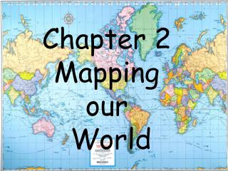
Mapping Our World
E N D
Presentation Transcript
Mapping Our World Latitude and Longitude • Cartography • Science of mapmaking • Uses imaginary grid of parallel lines and vertical lines to locate points on earth • Equator cuts Earth in Half
Latitude Latitude: lines running to the equator dividing the globe vertically into degrees north and south of The equator • Each degree of latitude= 111km on Earth’s surface • Each degree is further broken down into minutes and then seconds • Each minutes of latitude= 1.85 km • Each second of latitude= 0.031 km
Latitude • equator is @ 0 Degrees Latitude • 90 Degrees North Latitude is North Pole • 90 Degrees South Latitude is the South Pole • 23.5 Degrees North Latitude is Tropic of Cancer • 23.5 Degrees South Latitude is Tropic of Capricorn
Longitude Longitude: lines used to locate positions East and West of the Prime Meridian • Each degree of longitude is 111 km at the Equator and is further broken down into minutes and seconds • Distance between lines of longitude change-largest at the equator and smallest at the poles. • Unlike lines of Latitude, lines of Longitude are not parallel but are semicircles running from pole to pole • Distance between degrees of longitude are not equal, unlike the distance between degrees of latitude; smaller distance closer to the poles. • When using coordinates to locate a specific point, degrees of latitude are given first followed by degrees of longitude
Longitude • Prime Meridian is @ 0 Degrees longitude through Greenwich England • Points west of P.M. are numbered 0-180o west • Points east of the P.M are numbered 0-180o east • International dateline is opposite P.M. when crossing you going west, add a day, when crossing going East subtract a day
Time Zones Time Zones: 24 different time zones on Earth, Why? (it takes the earth 24 hours for 1 rotation) • Each zone is = 15 Degrees wide, adjusted to local areas to reduce time zone confusion • United States has 6 time zones
Need a Date for Homecoming ? Call the … International Date Line Calendar Dates: days based on Earth’s rotation, just as time zones are, so when passing through time zones, you either gain or lose time • On the international dateline, 180 Degrees from the Prime Meridian, days are lost and gained • Traveling west across the prime meridian you gain a day • Traveling east across the prime meridian you lose a day