Download
1 / 27
290 likes | 417 Vues
Explore the glacial history of the Puget Lowland through features like kettles, eskers, and erratics. Discover the complexities of Quaternary stratigraphy and the challenges in interpreting glacial advances. Vic Prest’s reconstruction of the Cordilleran Ice Sheet is a key reference in understanding the region’s icy past.

E N D
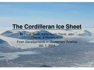
The Cordilleran Ice Sheet By Derek Booth, Kathy Goetz Troost, John Clague, & Richard Waitt From Developments in Quaternary Science Vol. 1, 2004
Vic Prest’s (Canadian Geological Survey) reconstruction of the Cordilleran Ice Sheet has stood the test of time. Even his age constraints on the timing of deglaciation has fared well with additional radiocarbon dating.
We now recognize that the Puget Lowland was occupied with glacial ice many times in the past and as recent as ~15,000 years ago.
The Alaskan tidewater glacier provides a nice analog to the glacial setting of the Puget Lowland during deglaciation ~15,000 years ago.
Glacial features such as kettle and kames, glacial marine deltas and ice-streamlined topography are seen on the 10 m DEM image of central and south Whidbey Island. Ice-flow direction North Penn Cove Kettle & Kame Post-glacial marine delta
The Vashon Till is well-exposed near the top section of many bluffs lying adjacent to the Puget Sound.
Mt. Erie, Fidalgo Island is a classic stoss and lee landform. Ice flow was from your right to left (north to south) on the image.
Glacial grooves and striations are preserved on quartzite bedrock overrun by the Puget ice sheet.
Diverse lithology of glacial erratics and till boulders reflects the diverse bedrock lithology that was eroded and deposited by the Puget Lobe.
Coupeville erratic (Whidbey Island) was plucked from the lee side of Mt.Erie lying ~20 miles north of Coupeville.
Wedgewood erratic (near NE75th St. and 28th Ave) is one of the larger glacial erratics in the Seattle area. It is a greenstone and may have also been excavated from Fidalgo Island.
The Saratoga erratic (south Whidbey Island) is one of my favorites. It is over 30 feet tall and big enough to eat lunch on it. It was also excavated from Mt. Erie, Fidalgo Island.
The large Columbia basalt haystack erratics were excavated by the Okanogon Lobe from the Columbia Gorge and deposited north of Withrow, Washington.
How would you explain the presence of this large Whidbey Island erratic lying 250 feet above sea level without a context of “glacial theory?”
“Field investigations Puget Lowland show that ice sheets have advanced south into the lowlands of western Washington at least SIX times” (18) BUT….. The MARINE OXYGEN-ISOTOPE RECORD suggests that there were MANY more; possibly 20-30 glacial advances in the last 2.5 million years.
Why don’t we see evidence for so many glacial advances? • Obliterative Overlap(recurring glaciations “erase” records of previous glaciations) • Tectonic deformation: “the bedrock and overlying Quaternary sediment in the Puget Lowland have been deformed…other faults cross the glaciated lowlands both N and S of the Seattle fault, with likely displacements of meters to tens of meters, thereby complicating interpretation of the Quaternary stratigraphic record” (20) • Lack of significant advance into this region
Fig. 2 Marine Oxygen Isotope Curve (MIS) Stuck Orting Double Bluff Possession Salmon Springs
Fig. 5 - Locations of recognized pre-Fraser stratigraphic units: • Possession Drift • Double Bluff Drift • Salmon Springs Drift • Orting Drift • Stuck Drift 2 1 3 5 4
Fig. 7aPossession Drift (Pre-Fraser) stratigraphic section from Point Wilson, Whidbey Island
Fig. 7b Pre Fraser lithologies of Double Bluff, Whidbey Island (Double Bluff Drift)
Fig. 7c Pre Fraser stratigraphic section from the Puyallup River Valley (Stuck Drift)
Much of the sediment record exposed in unconsolidated bluffs lying adjacent to the Puget Sound are glacial in origin. Non-glacial sediment units, mainly alluvium are present in the lower exposed sections. This image was taken from the Double Bluff, Whidbey Island.
Marine limit (m) Whidbey Island Isostatic effects and relative sea level.