Download
1 / 17
190 likes | 399 Vues
Space Weather Research and Operations Using Incoherent Scatter Radar. Terrance G Onsager International Affairs Coordinator NOAA Space Weather Prediction Center Terry.Onsager@noaa.gov. Acknowledgements. Tony van Eyken, SRI International Esa Turunen, EISCAT Bob Robinson, NSF

E N D
Space Weather Research and Operations Using Incoherent Scatter Radar Terrance G Onsager International Affairs Coordinator NOAA Space Weather Prediction Center Terry.Onsager@noaa.gov
Acknowledgements • Tony van Eyken, SRI International • Esa Turunen, EISCAT • Bob Robinson, NSF • Rich Behnke, NSF • Joshua Semeter, Boston University • Mihail Codrescu, NOAA
Main Points • Space has become an integral component of our economic and security infrastructures • Understanding and predicting the dynamics of the coupled Earth-Space system is critical to the viability of our economic and security infrastructures • Incoherent Scatter Radar provide key data for scientific understanding and to develop and drive data-assimilation models of the Earth-Space system • Modern ISR also allow continuous, real-time data acquisition that can drive operational models to protect our economic and security infrastructures • Recommendation is to broaden the ISR user community to foster interdisciplinary science across the full Earth-Space environment and explore contribution to operational space weather applications
Economic and Security Infrastructures Impact Areas • GNSS • Degradation of accuracy or availability • Strong growth in applications – surveying, drilling, precision agriculture, navigation, aviation • Aviation • Disruption of communication and radiation risk • The Next Generation and Single European Sky Air Transportation Systems will depend on GNSS • Space Systems • Degradation or loss of satellite capabilities • Satellite tracking and orbital debris • Electric Utilities • Potential for significant disruption of service with $Trillion consequences
Solar Cycle 24 Has Begun Anomaly assessment report available
EU-U.S. Cooperation in Space Weather Emergency Management • Responding to Transatlantic Impacts of Geomagnetic Storms • Federal Emergency Management Agency • NOAA Space Weather Prediction Center • EU Monitoring and Information Centre • EU Institute for the Protection and Security of the Citizen • Swedish National Power Grid • National Electric Safety Board of Sweden
Space Situational Awareness • Space Weather is one of three pillars of the European SSA System • Observations, modeling, research, and services • Opportunities for EU-US partnerships in the SSA Program • Each partner can specialize in areas of expertise and then coordinate • Complementary ground-based and space-based sensors • Complementary prediction models and ensemble forecasts • Shared knowledge of societal impacts and mitigation methods • 7th Framework Program • EU-U.S. cooperative activities are occurring
The NSF Incoherent Scatter Radar Chain-2007 Sondrestrom (SRF) PFR 2007 AMISR-Poker Flat Millstone Hill (MH) SRF 1982 SRF 1982 MH 1962 MH 1962 Jicamarca (JRO) AO 1962 AO 1962 JRO 1963 JRO 1963 Arecibo (AO) NSF-supported ISRs--2010 The NSF Incoherent Scatter Radar Chain-2006 Sondrestrom (SRF) Sondrestrom (SRF) AMISR- Resolute Bay (RISR-N) RISR-N 2009 PFISR 2007 SRF 1982 MH 1962 AO 1962 Millstone Hill (MH) Millstone Hill (MH) AMISR-Poker Flat (PFISR) Jicamarca (JRO) JRO 1963 Jicamarca (JRO) Arecibo (AO) Arecibo (AO)
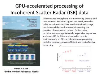
ISR Measurements – Fundamental to Understanding Earth-Space Environment Fundamental plasma properties Precipitating particle properties Electric fields, plasma convection, currents Neutral winds, gravity waves Ion and neutral composition
RISR-N,S 2011 PFR 2007 SRF 1982 MH 1962 AO 1962 JRO 1963 The NSF Incoherent Scatter Radar Chain-2007 Future AMISR Deployments OR: • The existing chain of radars will continue to grow with the blossoming of AMISR systems at other locations. • RISR-S: A Canadian owned AMISR system at Resolute Bay • Major Research Instrumentation (MRI) to put a small AMISR system near Buenos Aires, Argentina • Proposal under consideration to construct two AMISR radar systems in the Antarctic • Possible replacement of existing incoherent scatter radars with AMISR systems Sondrestrom (SRF) Sondrestrom (SRF) PFR 2007 SRF 1982 SRF 1982 AMISR-Poker Flat MH 1962 MH 1962 AO 1962 AO 1962 Millstone Hill (MH) Millstone Hill (MH) Jicamarca (JRO) Jicamarca (JRO) JRO 1963 JRO 1963 Arecibo (AO) Arecibo (AO)
Increase in Incoherent Scatter Radar Data Value through International Polar Year Efforts • EISCAT led an effort to operate ISR on a near-continuous basis (2007 - ) • Created the most extensive polar atmosphere data set • Proved invaluable for modeling efforts and basic research • Challenged modelers to address long-term, global coupling under diverse conditions • Revealed feasibility and value of continuous data and need for significant model improvements Low Duty Cycle Full Power
Current EU-U.S. ISR Cooperative Activities • Joint planning of ISR World Day observations • Joint participation on related panels, committees, and science workshops • Joint participation in EISCAT and AMISR summer schools • Plans for continuation of U. S. – EISCAT Post-Doc Program • U. S. participation in EISCAT-3D development program considered • EISCAT contributing to U.S. ISR strategic planning
Opportunities • Multi-disciplinary use of ISR-facility data can be significantly enhanced to accelerate scientific progress and to provide accurate predictions to support the growing need for space weather applications • Existing European programs, such as 7th Framework and Space Situational Awareness, are good vehicles for cooperation • Increase to next Solar Maximum (2013) is an opportunity to test and improve our understanding of extreme conditions and utilize extensive space and ground based assets • Existing international coordination of ISR research is a good foundation for expansion to multi-disciplinary community • Combination of campaign mode and continuous operation enhances scientific value and enables the development of data-assimilation techniques
Obstacles • Collaborative EU-U.S. programs are impeded by differences in funding mechanisms, review processes, and timelines • U.S. participation in 7th Framework Program is limited by legal restrictions • ISR data are not effectively utilized by the broad, interdisciplinary research community • Data formats are specific to ISR and not familiar to scientists outside ISR community • Measurements are complex and interpretation can be difficult for non-experts • There is a lack of awareness of the availability of the new continuous ISR operations
Recommendations • Expand the worldwide and multi-disciplinary community of users to foster interdisciplinary research and applications (develop a user base similar to that of astronomical observatories) • Foster the development of Earth-Space system models that exploit these data and advance our science and applications for societal benefit (arrange cost sharing with agencies responsible for space weather applications) • Establish processes for the coordination and review of proposals to support large international programs • Maintain strong information exchange, global coordination, and strategic planning to optimize scientific studies and technology development