Cedar Lake Water Monitoring Sites: A Comprehensive Overview
Explore groundwater and surface water elevation monitoring sites surrounding Cedar Lake. Discover Phase I, II, and Augmentation Feasibility Study locations for detailed water data assessments.

Cedar Lake Water Monitoring Sites: A Comprehensive Overview
E N D
Presentation Transcript
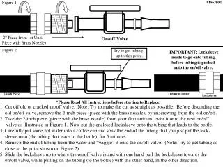
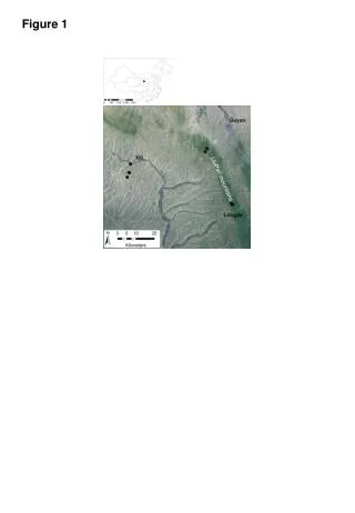
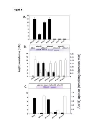
FIGURE 536 E. Michigan Ave., Suite 300, Kalamazoo, MI 49007 phone (269) 344-7117 fax (269) 344-2493 Lake Outflow Site #1 north of 4484 E. Cedar Lake Dr. Site #2 3481 W. Cedar Lake Rd. Site #3 7588 Teal Site #4 4840 E. Cedar Lake Dr. Site #5 6967 Lakewood Dr. Site #6 7906 W. Cedar Lake Rd. Site #7 4795 W. Cedar Lake Rd. Jones Site #8 4884 Arron Dr. Site #9 7448 Lakewood Dr. Site #10 7173 Huntington Dr. Site #11 Lot north of 6933 Huntington Dr. Site #2 Site #7 Site #1 Sherman 1 Sherman 2 King’s Corner Site #4 Site #6 Staff Gauge Sites 1-3 were original Phase I monitoring locations. Sites 4-7 were added as part of Phase II monitoring efforts. Sites 8-11 were added as part of Augmentation Feasibility Study efforts. Site #8 Site #3 Site #9 Site #10 Site #11 Site #5 Map of groundwater and surface water elevation monitoring sites located around the perimeter of Cedar Lake. FIGURE 1